Residents shared information through MapaKalamidad.ph in support of response efforts as a fifth storm hit the region in just two weeks.
The Philippines experienced five consecutive typhoons in late October and early November. While still recovering from Typhoon Molave (Quinta), Typhoon Goni (Rolly). Taifun Atsani (Siony), and Taifun Etau (Tonyo), rains lashed the eastern and northern parts of the country and compounded the impact of Taifun Vamco (Ulysses), the fifth storm to hit the region in just two weeks.
The typhoon left severe impacts on roads making them impassable due to flooding, and disrupted power and communications. The state of reservoirs in some areas exacerbated flooding in low-riverine areas such as Cagayan Valley, Central Luzon, Cordirella Administrative Region and Metro Manila.
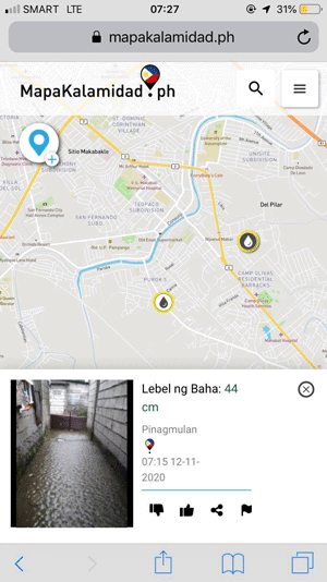
Amidst the widespread flooding situation that halted the activities and movements of the people of the Philippines, the hashtags @FLoodPH and #RescuePH were trending on social media, where people called for help and posted flood information in their areas. MapaKalamidad.ph, a newly launched disaster information platform, has capitalized on the active social media presence to aid community-based risk reduction. Using an AI-based chatbot to monitor and respond to social media posts, the platform collects and confirms reports from citizens into real-time flood maps. The platform saw a significant increase in activity during Typhoon Ulysses due to active citizens reporting updates on the flood situation. The free and open web-based maps have been used to support citizens and disaster management units to identify areas in need of response and rescue. MapaKalamidad.ph was launched in late September 2020 as part of the PhilAWARE Program supported by the U.S. Agency for International Development Bureau of Humanitarian Affairs (USAID BHA) in collaboration with the Philippine Office of the Civil Defense (OCD), Pacific Disaster Center (PDC), and Humanitarian OpenStreetMap Team (HOT).
Joseph Curry of USAID BHA said,
“While we rely on the government as the authority in charge of impact and relief, we also recognize that the affected parties have the most up-to-date information and play an important role. MapaKalamidad.ph adds a dimension to data and information by empowering citizens to report disasters, conditions and damages in their neighborhoods through social media and apps. In the spirit of bayanihan, MapaKalamidad.ph becomes a shared tool in disaster response, connecting each barangay with the higher levels of government.”
Recent unpredictable typhoons have underscored the importance of real-time, verified information in supporting response efforts under volatile conditions. As the storm quickly turns and floods inundate the country, netizens using the platform have great potential to be a key resource in sharing flood map information to aid safety and response decision-making.
MapaKalamidad.ph is currently available for Quezon City and Pampanga residents where citizens can share flood information anonymously via Facebook message @mapakalamidad, or Telegram message @kalamidadbot. Government agencies are also monitoring the map to respond to disaster situations and provide assistance to residents.
With La Nina conditions continuing, heavy rains are expected in the region in the coming months. The Disaster Map Foundation encourages Filipinos to share critical information to help others, the government, and response teams in the event of a disaster.
Check https://mapakalimad.ph for flood updates and stay safe!
MapaKalamidad.ph is part of the USAID DisasterAWARE Program for ASEAN Regional and National Capacity Development for Hazard Monitoring.
MapaKalamidad.ph is made possible through the support of the American people through USAID, and through collaboration with partners such as the Pacific Disaster Center at the University of Hawaii and the Humanitarian OpenStreetMap Team; implementation partners Office of Civil Defense, National Disaster Risk Reduction and Management Council, Pampanga Disaster Risk Reduction and Management Office and Quezon City Disaster Risk Reduction and Management Office; data partners including Twitter and Mapbox.
Leave a Reply