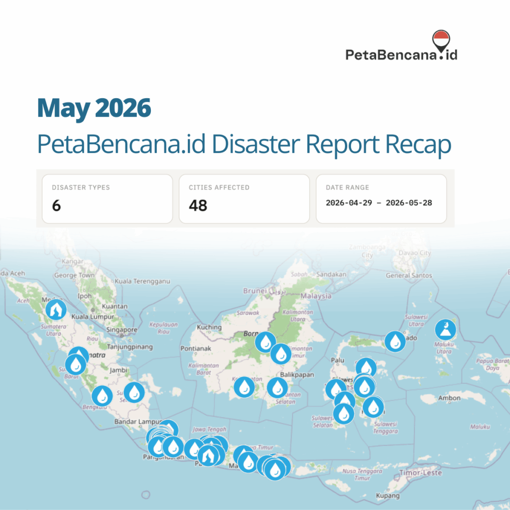
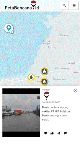
Across hundreds of resident reports submitted to the real-time disaster map, PetaBencana,id during May 2026, floods were not only associated with heavy rainfall itself, but with failing infrastructures, drainage systems reaching capacity, tidal flooding creeping further inland, and water lingering long after storms had passed. In addition, several reports in May described flooding that arrived on top of conditions already in distress, or that triggered secondary disasters more destructive than the accumulation of water.
This points to several important shifts in how disasters are unfolding.
Flooding is becoming increasingly difficult to predict because the hazard is no longer limited to rainfall alone. Water now moves through landscapes already shaped by accumulated vulnerabilities: overloaded drainage systems, unstable riverbanks, saturated soil, land subsidence, erosion, and infrastructure under constant pressure.
In many cases the accumulation of water is not the primary disaster, but the trigger or context for structural failure. Several reports described landslides, road collapses, or bank erosion as the primary event: a landslide along the Kali Ciliwung in Depok (May 27); a landslide in Kampung Ardio, Kota Bogor (May 2); a cliff collapse onto a road in Ciamis (April 28); road erosion cutting off two villages in Lebong, Bengkulu (May 8). These sudden failures are often the most destructive because they emerge from conditions that are difficult to model precisely and unfold rapidly in dense and interconnected environments. This is why real-time information becomes increasingly important for save navigation and response.
Communities are reporting conditions that persist, recur, or compound; disasters unfolding on top of previous disasters. Several regions appeared repeatedly in the reports, particularly areas along the north coast of Java. Accumulated risk places increasing and constant stress on infrastructure, increasing the likelihoods of ‘sudden’ failures, or failures unanticipated in prediction models. Jl. Raya Sapan in Kabupaten Bandung flooded on May 21 and again on May 26, two separate reports from the same street within five days. Kutai Barat and Mahakam Ulu both reported river overflow from the Sungai Mahakam system within a day of each other on May 18 and 19. In Cianjur, a banjir bandang (flash flood) struck Desa Jamali on the night of April 30, with a report filed on May 1 noting that water had still not receded by the following day, with depths reaching 50 centimeters in residential areas. In Demak between May 13-26, the water rose to above 1 meter, fell to 36 cm, and rose again above 1 meter. For many communities, flooding is experienced as prolonged instability.
As climate patterns become less predictable, adaptation will depend not only on forecasting hazards, but on understanding how risk accumulates across neighborhoods, river systems, and everyday infrastructure. What communities are documenting through PetaBencana can function as a kind of early trigger system; not only for emergency response, but for identifying deeper shifts in environmental and infrastructural stress before they fully emerge as large-scale disasters.
One report submitted to PetaBencana in March stood out:
“Banjir yg tak pernah diketahui publik, pasti daerah ini selalu ke skip.” “Flooding that the public never knows about—this area always gets skipped.”
It is a short message, written in frustration, but it captures a deeper problem in how disasters are measured and understood. Many floods never appear in official datasets, risk models, or media coverage. They occur in small neighborhoods, on residential streets, or along overlooked drainage corridors. They may not meet the threshold of a “major disaster,” but they still disrupt daily life; flooding homes, blocking roads, and isolating communities.
Traditional flood risk models often rely heavily on rainfall data, river gauges, and historical flood maps. While these tools are essential, they can miss important details about how flooding actually unfolds on the ground. Urban drainage failures, localized river overflows, blocked canals, and changing land use patterns can all produce flooding that is highly localized and difficult to detect through remote sensing or rainfall-based modeling alone.
Community reporting is critical in surfacing these blind spots, identifying the areas most affected.
Mapping Hidden Floods
Throughout March, communities across Indonesia used PetaBencana to report hazards affecting their neighborhoods. Flooding was by far the most frequently reported event, with reports coming from Jakarta, Tangerang, Bogor, Aceh, Lampung, and East Java.
A clear pattern emerged in many of the descriptions: flooding was seldom a result of heavy rainfall, but to river systems and drainage corridors reaching their limits.
While many flood risk assessment focus primarily on rainfall intensity and river levels, climate change is not only increasing rainfall extremes, it is altering how water moves through cities and landscapes.
Urbanization reduces natural absorption through soil and vegetation. Drainage networks designed for historical rainfall patterns are often pushed beyond capacity. Rivers that once overflowed occasionally may now breach their banks more frequently.
The result is a growing number of hyperlocal flood events that occur outside traditional monitoring systems.
Platforms like PetaBencana help capture these shifts by documenting what communities experience in real time. When residents report rising water levels, blocked roads, or overflowing rivers, they are effectively creating a distributed network of observers, adding a critical layer of information that cannot be captured by rainfall sensors or satellite imagery alone.
In several areas, residents reported water remaining for multiple days, with some neighborhoods still inundated long after the initial rainfall had stopped. One report noted flooding that had persisted for three days, while others described water levels reaching waist height in residential areas.
This type of prolonged flooding is rarely captured in conventional flood models, which tend to focus on peak water levels during storm events. Yet for communities, the duration of flooding can be just as significant as its height. Prolonged inundation damages homes, disrupts livelihoods, and increases health risks.
By documenting conditions over time, community reports help reveal how disasters unfold beyond the moment of impact.
The knowledge of how floods unfold in neighborhoods—where water accumulates, which streets flood first, how long water remains—often exists only with the people who live there. Yet this knowledge rarely makes its way into the datasets used for disaster planning, risk modeling, or emergency response.
When this local knowledge becomes part of the data used to understand disasters, decision-making becomes far more grounded in reality.
As climate change reshapes rainfall patterns and urban flood dynamics, this kind of real-time documentation becomes even more valuable. It provides decision-makers, responders, and communities themselves with a clearer picture of where risks are emerging and how they are evolving.
Reading the report description “flooding that the public never knows about — this area always gets skipped,” we are reminded how much knowledge sits inside these short descriptions. When we built PetaBencana.id, this is exactly the kind of gap we were trying to address. Each report carries local memory, and there are thousands of these observations shared via PetaBencana.id. Together they form a growing archive of how disasters are actually experienced on the ground.
If there is one lesson from these “hidden floods,” it’s the people living with risk are often the ones who understand it best.
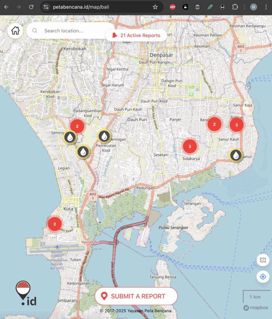
Bali is currently grappling with widespread flooding and extreme weather after several days of intense rainfall, strong winds, and unstable conditions across the island. Since 22 February 2026, heavy rain has saturated much of Bali — especially in Denpasar and Badung — leading to flooding in at least 26 locations, with water levels ranging from roughly 30 to 80 cm along streets and residential areas. Local disaster and rescue teams have been actively conducting evacuations and emergency responses amid ongoing precipitation.
Across Denpasar city and surrounding regencies, authorities have recorded not only flooded roads and homes but also ancillary impacts such as landslides and fallen trees. In some neighbourhoods, wind damage and riverbank breaches compounded the challenges faced by residents and first-responders.
As the continuous downpour overwhelms parts of Bali’s drainage infrastructure, leading to significant inundations in areas such as Sanur, Renon,Sesetan, and Legian, residents and responders are turning to PetaBencana.id, to view and share live conditions and navigate safely.
During the ongoing Bali floods, PetaBencana.id functions as more than an information website, it operates as a live coordination layer between communities, responders, and decision-makers.
As residents report where flooding is actively occuring, which roads are no longer passable, and which neighborhoods are in need of urgent evacuation, emergency services and first responders have swiftly responded.
This year’s wet season — typically spanning late December through February — has brought higher-than-average rainfall and volatile weather. Meteorological agencies warn that medium to extreme rain could persist through 24–26 February, raising concerns that further flooding remains possible in low-lying areas and along major waterways.
We remind residents to stay informed, stay safe, and share what you see via PetaBencana.id so we can continue to help eachother.
In November 2025, a series of typhoons and cyclones struck cities across Viet Nam, the Philippines, Thailand, and Indonesia. As national governments mobilized response measures, the damage and the death toll, raised urgent questions about preparedness rather than response alone.
For more than a decade, ASEAN has built an elaborate disaster-management architecture, anchored in the ASEAN Agreement on Disaster Management and Emergency Response (AADMER) and reinforced through regular ministerial meetings, coordination mechanisms, and humanitarian assistance and disaster relief exercises.
The events of late 2025 offered a critical moment to assess how these frameworks function in practice. It was in this context that Pusat Studi Asia Tenggara (PSAT) convened a public discussion titled “Rethinking Disaster Management in Southeast Asia.” The conversation focused on a fundamental question: if disaster risks are well known and regional mechanisms are already in place, why do large-scale disasters continue to produce the same outcomes across ASEAN member states?
Environmental activist Puspa Dewy from WALHI situated disasters within a broader political and policy context. Floods, landslides, forest fires, and haze, she argued, are not random natural events but the cumulative outcomes of development choices, particularly deforestation, extractive industries, and large-scale land conversion.
As forests are cleared, peatlands drained, and rivers reshaped to accommodate development, natural hazards are transformed into disasters. The resulting risks and losses are borne disproportionately by communities that derive little benefit from these projects. Framing such events as “natural,” she noted, obscures responsibility and weakens accountability for the decisions that create vulnerability.
From WALHI’s perspective, disaster management cannot be treated as a purely technical or humanitarian issue. It is inseparable from land governance, corporate influence, and the state of democratic space. When communities raise concerns about environmental risk, they are frequently sidelined or intimidated, limiting their ability to participate meaningfully in prevention and oversight. In this context, improving disaster outcomes requires not only better response mechanisms, but stronger policies, enforcement, and protection for civic participation.
From the government’s perspective, Dr. Raditya Jati of BNPB argued that Indonesia already has the core frameworks and long-term roadmaps needed for effective disaster management, but continues to face challenges with implementation due to institutional silos and uneven implementation at the local level. Dr. Jati advocated for a model of sustainable resilience that integrates disaster risk management, climate adaptation, and development planning into a single policy approach, emphasizing that national resilience cannot be achieved without strengthening local capacity, governance, and coordination where hazards directly intersect with communities and infrastructure.
Taking the discussion to the regional level, Venkatachalam Anbumozhi from ERIA reframed disasters as a macroeconomic issue. Southeast Asia, he noted, experiences a disproportionate share of climate-induced disasters, losing an estimated two to three percent of GDP annually as a result. Despite this, governments continue to spend far more on emergency response than on long-term risk reduction. The reason, he suggested, is political economy. Disaster prevention requires long-term investment, while political cycles are short. Prevention rarely produces ribbon-cutting moments or immediate political rewards.
Yet treating disaster resilience as a cost rather than an investment is economically irrational. Without embedding disaster risk reduction into development and financial planning, Southeast Asia’s growth model will remain fragile and self-defeating.
Nashin Mahtani of Yayasan Peta Bencana, argued that ASEAN’s approach to disaster management reflects a deeper hesitation to act collectively. While ASEAN often describes itself as a family, she suggested that resilience is still treated primarily as a national responsibility rather than a shared regional asset.
Mahtani urged ASEAN to reconceptualize resilience as a regional public good, something that gains value when shared, scaled, and jointly maintained. This shift, she argued, should extend beyond emergency response to include preparedness, mitigation, and system-building. Drawing on the work with Yayasan Peta Bencana she pointed to concrete examples where shared infrastructure and interoperable data enabled successful scaling across borders. Yet across ASEAN, she noted, fragmentation remains the norm: countries repeatedly build parallel systems rather than multiplying impact through collaboration, a pattern seen clearly during the COVID-19 pandemic and replicated in disaster management platforms. If ASEAN truly understands itself as a family, she concluded, solidarity cannot begin only when one member is overwhelmed, it must also mean working collectively to ensure fewer members reach that breaking point in the first place.
For PetaBencana, this is not an abstract proposition. The tools, practices, and partnerships needed to treat resilience as a regional public good already exist. Community-generated data, open infrastructure, and interoperable systems have proven their value not only in accelerating response, but in strengthening trust between institutions and the people they serve. The question facing ASEAN is no longer whether collaboration is possible, but whether it is willing to scale what already works.
As disasters grow in frequency and complexity, no single country can manage risk in isolation. Resilience that is built collectively is stronger, faster, and more equitable than resilience built alone. If ASEAN is serious about responding “as one,” that commitment must extend beyond emergency moments to the quieter, harder work of preparedness, shared systems, and mutual trust.
The PSAT discussion made clear that improving disaster outcomes will require more than faster response or better coordination during emergencies. It demands political choices that prioritize prevention, integrate disaster risk into development planning, and enable meaningful participation from communities most affected by environmental change. At the regional level, it also requires ASEAN to move beyond parallel national efforts toward genuinely shared systems and approaches.
On September 10, 2025 Bali experienced one of its worst flooding events in history, triggering the provincial government and the National Emergency Management Agency to declare a state of emergency. Severe flooding across Denpasar, Kuta, and surrounding districts, inundated homes and major roads, and forced evacuations.
Within 24 hours, over 130,000 people used PetaBencana.id to view and share real-time flood updates, as the platform turned into a vital lifeline for residents, volunteers and authorities to coordinate safe navigation and to prioritize evacuation.
Residents in Perumahan Kalista and Kampung Jawa posted urgent updates on rising water levels along the Ayung and Tukad Badung rivers. These reports enabled first responders to direct evacuation teams to the riverside settlements before floodwaters became impassable.
Motorists shared images of flooded stretches of Jl. Sunset Road and Jl. Kayu Aya. PetaBencana’s live map allowed residents to avoid gridlocked intersections and reroute around submerged sections of the road.
In Kesiman Kertalangu, residents reported that 18 homes in Perumahan Pesona Kartika Tohpati were fully inundated. These crowd-sourced reports were used by volunteers to organize sandbagging and to assist families in relocating to higher ground.
Updates about the overflow of Sungai Taman Pancing guided responders in deploying boats and assisting families trapped along Jl. Taman Pancing Barat–Timur.
Emergency services confirmed that PetaBencana data was used alongside official coordination channels to deploy rescue teams and manage traffic flow. For many residents, the platform became a critical navigation tool that reflected rapidly changing conditions.
The intensity of the flood cannot be explained by rainfall alone. In urban centers such as Denpasar and Kuta, rapid development has left drainage systems unable to absorb sudden runoff, while climate scientists warn that extreme rainfall events like this are becoming increasingly frequent across Indonesia.
In many of these areas, residents reported water levels reaching up to an adult’s chest or head height, leaving entire housing complexes inundated and dozens of roads impassable. BMKG (Meteorology, Climatology, and Geophysics Agency) has warned of continued heavy rainfall across Bali in the coming days. Communities are urged to remain alert, monitor official advisories, and make use of PetaBencana.id to share and access real-time information on flooding.
“Today’s events underscore how quickly conditions can change,” said Nashin Mahtani, Director of Yayasan Peta Bencana (Disaster Map Foundation). “We encourage everyone to use the platform to report flooding in their neighborhoods and to check the map before traveling, so that together we can keep each other safe. Each report is an act of solidarity, together they give us the power to protect our families and to support one another.”
We are excited to continue building our software in solidarity with communities across the world.
As we grow, please refer to our official channels for the most accurate and current information about Disaster Map Foundation (Yayasan Peta Bencana) and our work.
Please note, we do not currently endorse or authorize any spin-off organizations, and we have no affiliates. If you come across initiatives claiming to represent or extend our work, feel free to verify with us directly.
Disaster Map Foundation (Yayasan Peta Bencana) remains the official steward of PetaBencana.id in Indonesia, MapaKalamidad.ph in the Philippines, and AafatInfo.pk in Pakistan, as well as the software that powers them.
At the recent UN climate negotiations in Bonn (SB62), talks have been marred by intense standoffs with little clarity on how the world will meet its adaptation goals. Recent discussions at the Intergovernmental Panel on Climate Change (IPCC) have failed to finalize the timeline for the Seventh Assessment Report (AR7), raising concerns about the availability of timely climate data for policy-making.
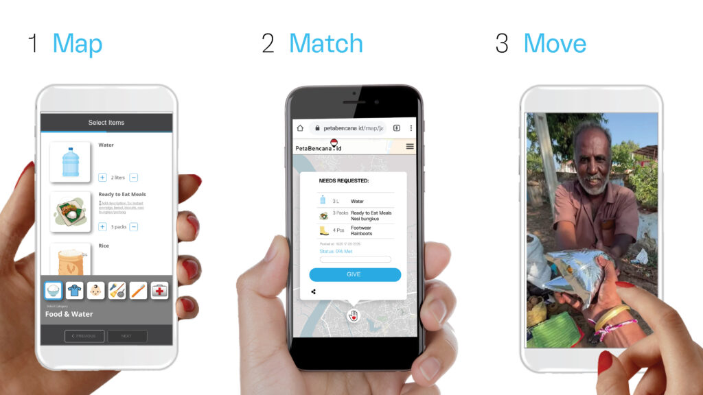
At a time when global climate science and action faces significant delays, local actors are stepping up to address the accelerating impacts of climate change. Today, we launched Peta Gotong Royong (Mutual Aid Map), a new AI-assisted platform designed to support peer-to-peer disaster relief, empower local action, and close critical gaps in humanitarian response. Built on the trusted foundation of PetaBencana.id — Peta Gotong Royong expands a decade-long commitment to strengthening community resilience through open, accessible technology.
“Communities must be equipped to act when disaster strikes,” said Nashin Mahtani, Director of Yayasan Peta Bencana. “Peta Gotong Royong builds upon the region’s strong traditions of mutual aid (“gotong royong”) by providing digital tools that match 21st-century challenges.”
Nashin Mahtani, Director of Disaster Map Foundation (Yayasan Peta Bencana) shared a preview of Peta Gotong Royong during the UN Global Platform for DRR in Geneva, where it received wide acclaim on the international stage.
Studies have shown that in the critical hours and days after a disaster, most life-saving actions and immediate aid come from those already on the ground. However, formal disaster response systems often struggle to integrate and support grassroots mutual aid effectively.
During disasters, social media platforms often become critical hubs for coordination and information sharing — but the sheer volume of posts can quickly become overwhelming, making it difficult to verify needs, prioritize responses, and ensure that aid reaches those who need it most. Peta Gotong Royong responds to these challenges by providing a free, open platform where anyone can report urgent needs, offer assistance, and be matched in real time — all using familiar tools like WhatsApp and mobile browsers. The platform is designed to harness the power of social media—where much of disaster response coordination already happens—and channel it into an organized, structured, actionable system that communities and volunteers can use.
“In times of crisis, it is communities that act as first responders. To build a more resilient Indonesia, we must continue to strengthen and harness the spirit of gotong royong (mutual aid), and one key way is through the use of PetaBencana.id. The risks we face can strike at any moment, and shared community-data through PetaBencana.id is both a vital contribution and a unique expression of gotong royong (mutual aid). The Mutual Aid Map (Peta Gotong Royong), as the latest initiative of PetaBencana.id, represents an important new form of collective action. Why is it called Gotong Royong (Mutual Aid)? Because it is leaderless, because we are all equal and we all work together to overcome the problems we face in our environments. The importance of this launch is to grow humanitarian support with Peta Gotong Royong by PetaBencana.id,” said Mr. Bambang Surya Putra, Director of Logistics and Equipment Management at the National Disaster Management Agency (BNPB) highlighting the importance of community participation in disaster response efforts.
Bambang Suryaputra, Director of Logistics and Equipment Management at the National Emergency Management Agency, highlights the importance of community participation via Peta Gotong Royong in disaster response efforts.
According to Indra Kurniawan, Head of the Disaster Management Department of Indonesian Red Cross Bogor 2015-2017 and also a Survivor of the Sukabumi Earthquake 2022,
“As a volunteer and community member who frequently responds directly to disaster sites, I truly understand the importance of fast and accurate information. Peta Gotong Royong by PetaBencana.id serves as a vital bridge—connecting residents, volunteers, communities, and the government—so we can recognize one another, support each other, and act together. It enables all stakeholders to easily identify unmet needs – whether it’s clean water, food, medicine – and respond more effectively. This is an important step forward in strengthening disaster response. I hope this tool continues to be socialized and used not only during disasters, but also in times of need. “
Already tested in early trial phases during the February 2025 floods, the platform demonstrated a 70% faster matching rate compared to conventional social media coordination alone.
“In March 2025, flash floods struck several areas in Padang Sidempuan, North Sumatra. Although I was far away in Deli Serdang, I coordinated with my colleagues from the Indonesian Red Cross (PMI) in Padang Sidempuan to submit a request for assistance through the Peta Gotong Royong feature on PetaBencana.id. A few days later, my request was answered by a donor, and the flood victims were able to receive much-needed basic supplies, such as sanitary products for women.
The Peta Gotong Royong feature is incredibly useful for communities. It allows us to request essential aid for disaster survivors quickly and effectively.
Indeed, PetaBencana.id is a powerful platform—not only for reporting disasters but also for facilitating mutual aid. We’re not just able to ask for help; we can also contribute and support others in need.”
Supriadi, Indonesian Red Cross (PMI) Deli Serdang, North Sumatra – Testimonial from a Peta Gotong Royong User
Zahrotul Ulya, Regional Executive Director of the Indonesian Family Planning Association in East Java underscored the importance of increasing community participation in disaster response and recovery. During the official launch event, she said
“Peta Gotong Royong by PetaBencana.id can invite more people to actively participate in providing assistance to those affected by disasters. With its easy access and transparent platform, communities feel more empowered to get involved and contribute meaningfully. The platform provides a tool to request a diverse set of needs including assistance for household needs, babies, children, and so on, providing a significant way to respond to specific needs during disasters.”
Echoing this statement, Al Razi Izzatul Yazid, Humanitarian Division Head of Rumah Zakat Indonesia emphasized the tool’s role in advancing locally-led humanitarian action, stating:
“The Mutual Aid Map (Peta Gotong Royong) by PetaBencana.id is a vital tool that helps identify urgent needs and empowers local communities, who are always the first responders in times of crisis. By supporting coordination and complementarity in humanitarian efforts, this platform embodies the core humanitarian commitment to effective, locally-led disaster response.”
I Nyoman Suartanu, from the Indonesian Hindu Dharma Council (PHDI), reflected on the cultural and spiritual resonance of the platform:
“Mutual aid is rooted in our humanity—it requires sincerity, volunteerism, and the willingness to rise above ego for the greater good. The latest initiative of PetaBencana.id, with Mutual Aid Map (Peta Gotong Royong), is not just a technological innovation; it is a moral call to unite across faiths and communities in the spirit of shared responsibility. At PHDI, our movement to love life aligns deeply with this initiative, and we are committed to strengthening disaster preparedness through collaboration, compassion, and collective action.”
The alignment with local wisdom was also praised by Yasser Atmanegara, Deputy Secretary of Muhammadiyah Disaster Management Center Jakarta, who stated:
“First of all I was very happy that this name was chosen appropriately because this is a technological breakthrough grounded in local wisdom, the spirit of gotong royong. Mutual Aid Map holds great promise as a platform for not only coordination, but collaboration, across organizations, enabling faster, more effective, and more direct aid distribution. It helps cut bureaucracy, supports peer-to-peer response, and becomes a vital record of public participation in disaster response and recovery. This shows how strong our society truly is when we work together.”
As Southeast Asia faces increasing climate risks, initiatives like Peta Gotong Royong demonstrate the potential of AI in enhancing disaster resilience and response. While global climate science navigates political challenges, local communities are taking proactive steps to safeguard their futures.
The platform also reflects broader trends toward decentralized disaster governance, as recognized in recent ASEAN frameworks on climate resilience. As global political delays threaten to slow global climate science and coordinated international response, innovations like Peta Gotong Royong offer a path forward — one where communities are not waiting for help, but leading the way.
Key Features of Peta Gotong Royong:
Real-Time Needs Reporting: Affected individuals can report their needs through the platform, allowing anyone to respond with precise and timely assistance.
Decentralized Matching System: Community members, local organizations, and volunteers can coordinate directly, reducing delays in aid distribution.
Open Data for Transparency: The platform maintains publicly accessible records of aid requests and fulfillment to enhance accountability and avoid duplication.
Seamless Integration with Social Media: Designed to work with popular messaging apps, making participation easy and accessible for a broad audience.
Heavy rain and strong winds have caused flooding in several villages in South Sulawesi since Friday, February 7, 2025 (7/02/25). The popular tourist destination of Bali has also been severely affected, with disruptions to land, sea, and air travel. Floodwaters have inundated homes and public infrastructure, with some areas experiencing water levels reaching waist height. As floodwaters rose, PetaBencana.id, recorded a surge in community-generated reports, enabling emergency response teams to act swiftly in affected areas.
Reports submitted to PetaBencana.id from residents in Turikale District, Lau District, Bontoa District, Mandai District, Moncongloe District detailed flood levels ranging from ankle to waist-high. Community-led information sharing via PetaBenacna.id played an important role in shaping evacuation efforts. Verified community reports provided essential information to emergency response teams and volunteers to immediately direct aid to locations that need it most.
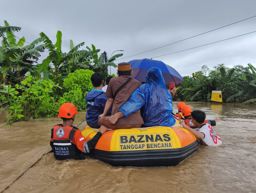
In response to reports posted on PetaBencana.id, BAZNAS teams quickly dispatched rubber boats to evacuate residents in flooded areas of Tanralili District, Borong Village, and Ammarrang Hamlet, Maros Regency.
Jumriah, a resident from South Sulawesi, underscored the role of community participation in shaping disaster response:
“As heavy rains and extreme wind continue to affect our area, PetaBencana.id allows us to support each other and strengthen community preparedness by providing a simple way to view and share disaster reports in real-time. Witnessing the quick response that has emerged from reports shared on the platform, I am increasingly aware that disaster mitigation is our shared duty and responsibility.”
As heavy rains continued, PetaBencana.id also received an increase in reports documenting the impacts of extreme wind, with incidents of fallen trees blocking roads and rooftops being blown off in Simbang, Tanralili, Turikale, Lau, Moncongloe, and Camba Districts. PetaBencana.id’s real-time data enabled local authorities and volunteers to quickly identify and clear blocked roads, ensuring the safe movement of residents and emergency responders.
TLDR; What happened to CogniCity? It grew up — got a passport, learned new languages, and thrived under the care of Disaster Map Foundation. So to reflect its development and maturity over the last 8 years, it’s getting a new name: Siti OSS.
Disaster Map Foundation [Yayasan Peta Bencana] proudly introduces Situational Intelligence Open Source Software (Siti OSS) as the new identity of our open source software that has been in continuous development since 2017. This renaming highlights the evolution of the software into an advanced, specialized, and uniquely equipped system that goes far beyond its origins to address today’s most urgent challenges.
Initially developed through academic research at the Smart Infrastructure Facility at the University of Wollongong (2013-2016) and MIT Urban Risk Lab (2016-2017), the software —formerly known as CogniCity OSS— has undergone radical transformation since MIT formally transferred the software and code to Disaster Map Foundation in 2017. In 2019, a pivotal development partnership with CivicDataLab further propelled the evolution of the software.
Together, Disaster Map Foundation and CivicDataLab have completely re-engineered the code into an enterprise-level disaster response coordination system built to meet the needs of users and partners. Since 2017, Siti OSS has been shaped by the real-world needs of frontline communities and the expertise of teams embedded in disaster-prone regions. Through years of active engagement with first responders, local governments, and at-risk populations, the platform has been continuously refined to meet the complexities of on-the-ground disaster coordination.
Through iterative development, the code base has been re-engineered to include expanded hazard and geographic coverage, automated notification systems, logistics coordination tools, expanded feature sets, and refined parameters that enable localization across different geographies and scales. A complete system architecture overhaul ensures the platform can handle event-driven usage spikes while maintaining top-tier energy efficiency. This code powers the award-winning platforms PetaBencana.id in Indonesia, MapaKalamidad.ph in the Philippines, as well as pilot platforms AafatInfo.pk in Pakistan and Mapeatudesastre.com in Panama. With its expanded capabilities and renewed identity, Siti OSS continues to set new standards in disaster coordination and climate adaptation technology.
Why the Name Change?
As our software has grown and diverged from its initial foundation, we recognize the need for a name that reflects its current state and future direction. Over 95% of the code has been completely reengineered, making Siti OSS fundamentally distinct in both structure and functionality, with only minimal elements of the original code (CogniCity OSS) remaining. This update ensures clarity for our users, collaborators, and the broader open-source community, preventing any confusion between our work and the legacy codebase from which it was forked.
Contributors
Since 2017, the development of Siti OSS has been led and stewarded by Disaster Map Foundation [Yayasan Peta Bencana], under the leadership of Nashin Mahtani and, since 2019, in partnership with Deepthi Chand and CivicDataLab. The software’s evolution into its current form is the direct result of these collaborations and the sustained efforts of teams embedded in disaster-prone regions.
All contributors are publicly and transparently recognized on our GitHub repository. This ensures a clear and accessible record of the community of developers and partners who continue to shape Siti OSS.
What’s Next for Siti OSS?
With this rebranding, we reaffirm our commitment to the continued development of Siti OSS as a powerful tool for situational intelligence and community-led information sharing. We invite the global open-source community to join us in shaping its future.
Siti OSS is evolving to cover broader aspects of crowd intelligence including crowd logistics, volunteer coordination, accessibility, scalability to multiple geographic locations. Siti OSS is also generalizing for domains outside disasters, applicable to a range of issues that would benefit from crowd intelligence. To explore the latest developments or contribute to the project, visit our GitHub repository: https://github.com/petabencana.
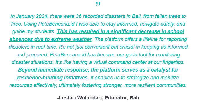
As 2024 — the hottest year on record — draws to a close, we are reminded that the story of this year is not just one of crisis, but of resistance, care, and possibility. It has been a year of escalating climate impacts, with record-breaking heat and a relentless cascade of disasters worldwide. Yet, in these moments of crisis, we also witness extraordinary ingenuity and solidarity as communities step forward to care for one another. PetaBencana.id and MapaKalamidad.ph were built to support this collective power. By leveraging what communities already know and do best – looking out for one another – these platforms have transformed smartphones and social networks into life-saving infrastructures, shaping systems of care that rise to the challenges of our time.
This year, that transformation took on new dimensions. This year alone:
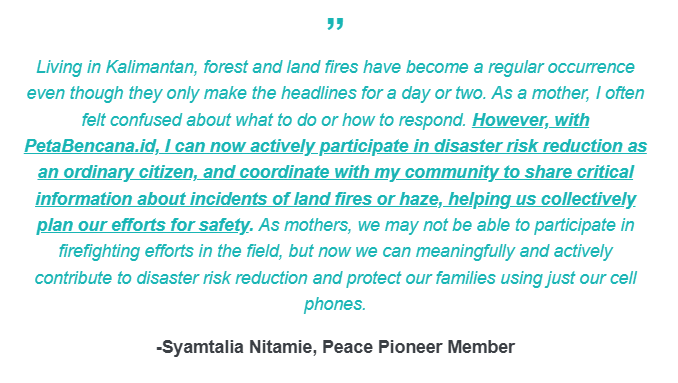
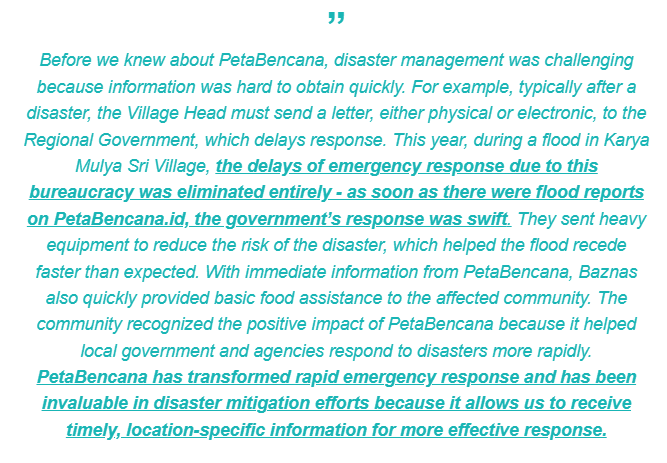
In 2024, our platforms experienced a 150% increase in resident-submitted disaster reports compared to the previous year. Every disaster report submitted is a reminder that resilience is not a solitary act. It is a neighbor marking a flooded road, a parent warning others of a fire, a community leader sharing critical updates. It is the collective intelligence of millions, brought together in real time to protect what matters most. We have received heart-warming messages from mothers, teachers , youth, emergency managers, responders on what it has meant to collectively participate in disaster risk reduction efforts:
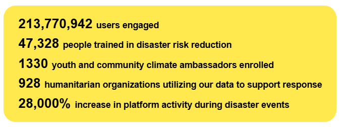
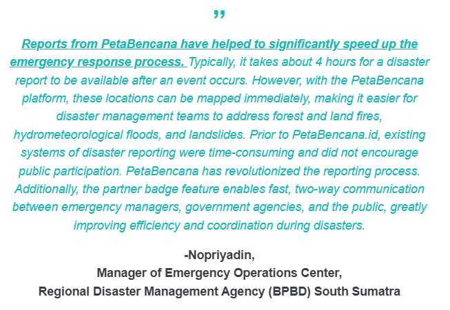
🌀 During Super Typhoon Carina (Typhoon Gaemi) in the Philippines, MapaKalamidad.ph received over 300 typhoon reports within a 36-hour period, and became a key line of communication between communities, local government units, and the Office of Civil Defense (OCD) as resident-reports helped shape and guide first response. This year, over 900 humanitarian organizations have been using the data from PetaBencana.id and MapaKalamidad.ph to support response, exemplifying the power of collective intelligence in transforming systems of care. According to Kasbu, emergency manager at the Regional Disaster Management Agency (BPBD) of Rokan Hilir:
🙋Our movement is sustained by the millions of people who share their knowledge, report disasters, support their neighbors, and contribute to building a future rooted in mutual care and collective resilience. A key catalyst for this movement is our network of youth and climate ambassadors, which this year grew to 1330 active ambassadors. We are proud and grateful to work with the next generation of leaders, who continue to demonstrate that even though youth are among the most affected by climate-related disasters, they are also leaders of change in their communities. Supported by our micro-grant programs, their proactive initiatives have collectively trained over 42,174 people in disaster preparedness this year alone. That’s a 350% increase in community-led initiatives compared to last year! 🤩
⭐We’ve marked some significant milestones this year:
At the start of the year, MapaKalamidad.ph expanded to a multi-hazard mapping platform for all of the Philippines. Less than a month after the launch, residents were already leveraging the newly integrated multi-hazard functionalities during the Earthquake in Caraga. Localizing our open-source software for the Philippines has been a deeply rewarding experience, showcasing how software can serve as vital knowledge infrastructure. By building on our work in Indonesia and sharing both technical tools, as well as strategies and lessons in community research, design, and outreach, we launched a multi-hazard platform in record time. It is a testament to the strength and importance of working on open source solutions for climate adaptation, as well as to the power of collaboration and knowledge exchange among the Global Majority.
In July, we marked a major milestone for climate adaptation with the launch of the first free real-time disaster notification service for all Indonesians. 🚨 This initiative addresses a profound challenge highlighted by the IPCC Sixth Assessment Report: the lack of locally-relevant, timely information as a critical barrier to effective climate adaptation. In just five months, over 24,535 notifications have been sent, bridging vital information gaps to help residents stay informed and act quickly. But this service is more than just a technical milestone—it is rooted in an understanding of how people perceive and respond to risk. By designing notifications informed by extensive research across diverse demographics, and integrating local knowledge, we ensure that these notifications translate into meaningful action.🙌 The stories that our communities have shared have reaffirmed that beyond technical platforms, PetaBencana.id and MapaKalamidad.ph are spaces for connection and agency. The collective spirit of gotong-royong in Indonesia and bayanihan in the Philippines, that have been renewed through these challenging times is a testament to the strength of community-led climate adaptation.